Change resolution to 320 by 240 [14 Kb]
Change resolution to 640 by 480 [50 Kb]
![Change resolution to 320 by 240 [14 Kb]](../320x240/213-1358.Edge.Pan.1.jpg.320x240.jpg.htm)
![Change resolution to 640 by 480 [50 Kb]](../640x480/213-1358.Edge.Pan.1.jpg.640x480.jpg.htm)
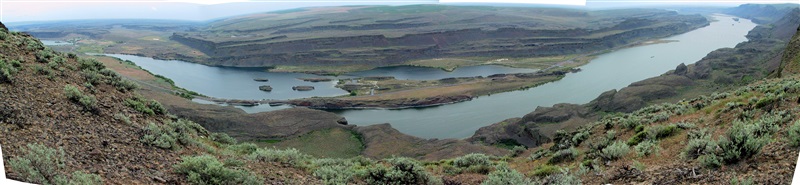
Вид с края обрыва. Восточные (центральные) районы штата Вашингтон. Май 2003.
Лагерь, где мы остановились, находился где-то слева в низине. Карта утверждала, что от того места наверх, практически к краю обрыва, ведёт объездная дорога. Но когда мы по ней поехали, оказалось, что "дорогой" это можно назвать весьма условно.
Во-первых, последние полкилометра её представляли собой проложенные через траву кучи камней и ухабов, так что ехать по ней можно было не быстрее 5 км/час. В результате две машины повернули обратно, но мы продолжили движение на моей вседорожной Тойоте Camry :).
Во-вторых, за километр до края обрыва мы встретили шлагбаум и металлическую сетку. Но даже это нас не остановило. Бросив машину, мы двинулись дальше пешком, и были вознаграждены: вид с края обрыва был просто великолепный!
Eastern (Central) Washington. May 2003.
Our camp was located somewhere at the left down this huge ravine. The map had a diversion road shown going from the camp to this point, so we decided to take it and get to the top of the surrounding areas.
Unfortunately, it turned out that the road was far from perfrect. At the last half mile it was so rought that 2 of 3 cars had to turn back, and only we four crazy continued this offroad trip at 3 mph on my Toyota Camry.
But even that road did not last much. At some point, it was just closed, so we had to leave the car and to take a walk towards our final destination. But that was worth it -- the vew was tremendously great!
Change resolution to 1024 by 768 [122 Kb]
![Change resolution to 1024 by 768 [122 Kb]](../1024x768/213-1358.Edge.Pan.1.jpg.1024x768.jpg.htm)
Change resolution to 1200 by 900 [166 Kb]
![Change resolution to 1200 by 900 [166 Kb]](../1200x900/213-1358.Edge.Pan.1.jpg.1200x900.jpg.htm)
Change resolution to 1600 by 1200 [295 Kb]
![Change resolution to 1600 by 1200 [295 Kb]](../1600x1200/213-1358.Edge.Pan.1.jpg.1600x1200.jpg.htm)
Change resolution to Full Size [2.7 Mb]
![Change resolution to Full Size [2.7 Mb]](../Htmls/213-1358.Edge.Pan.1.jpg.htm)